


On Friday, March 14, a tornado outbreak left a trail of destruction in Missouri, including the St. Louis area. This string of tornadic events and severe thunderstorms disrupted communities, killed 10 people in the state and raised concerns about severe weather preparedness.
The intense low-pressure system responsible for the tornado outbreak also generated straight-line and non-convective winds and an influx of warm, dry air across the region throughout the day.
As a result, sporadic wind damage occurred even before the line of storms arrived. These winds also sparked numerous wildfires across Missouri and Illinois.
After surveying damage, the National Weather Service (NWS) announced that 12 tornadoes touched down in the St. Louis County Warning Area.
Closer to the city, the area was littered with EF1s and EF2s, classifications on the Enhanced Fujita scale that measure tornado intensity based on wind speed and damage. One tornado touched down in Chesterfield, MO, at 9:16 p.m. and was on the ground for 37 minutes when it dissipated in Alton, Illinois, after traveling about 40 miles. This EF2 had peak winds at 122 mph, and was three-fourths of a mile wide at its largest.
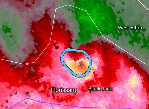
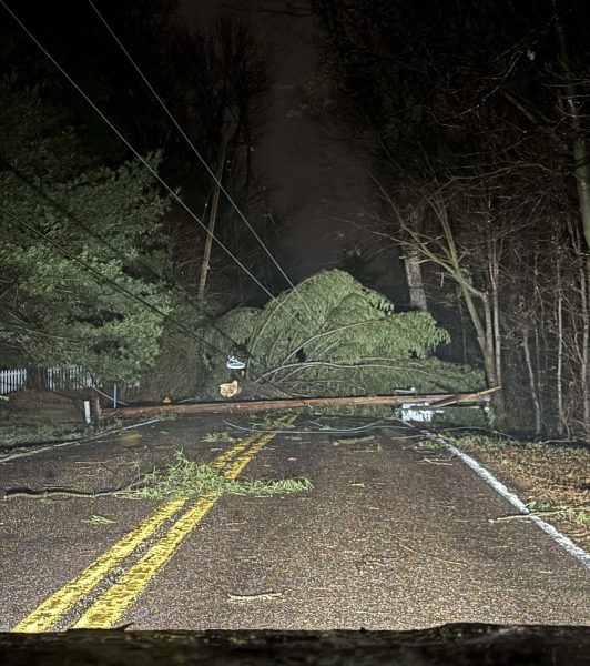
Maryland Heights, Florissant, and Old Jamestown were also in the storm’s path and sustained damage and power outages.
Joey Heitzler, a junior meteorology student, said he was monitoring this tornado as it came closer to his house in Old Jamestown.
“I saw my neighbor’s tall pine trees bending over so incredibly far, I don’t know how they didn’t break,” Heitzler said. “After that, I ran to the basement, and that is when I lost power.”
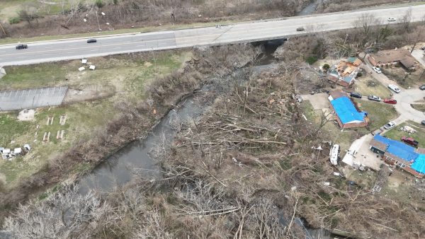
Another local EF2 was recorded south of the city traveling from Morse Mill to Mehlville Missouri, heavily damaging Arnold, Missouri. This storm was on the ground for 21 minutes and travelled 25.33 miles with winds of 115 mph.
Parts of the system traveled along both I-44 and I-70, affecting towns like Rolla and Columbia, Missouri. While Columbia only had strong winds and heavy rain, Rolla was struck by an EF2 tornado. This storm only lasted eight minutes, but in that time, it covered 9 miles with 120 mph winds and left devastating damage to the community.
Rolla is home to University of Missouri Science and Technology (MS&T). The university is home to 7,155 students.
MS&T sophomore Hayden Davies was in Rolla at the time of the storm. Davies lives just off campus at his fraternity house, which lost power during the event.
“I honestly didn’t realize the severity of the weather until the next day,” Davies said. “In our house we just noticed no power.”
How to prepare for the next storm
For college students – many of whom live in dorms or off-campus housing – being unprepared during different types of weather can be dangerous. Knowing how to stay informed and where to seek shelter is crucial, especially in states prone to severe weather events.
The first step to being a weather-prepared student is to understand the risks. Tornadoes can develop quickly, leaving little room for reaction. Thus, it is important to know the weather terms that meteorologists are using in their reports.
What is the difference between a tornado watch and a tornado warning? A tornado watch means that conditions are favorable for tornado formation. A warning means that rotation has been detected via radar and/or observed by a trained storm spotter.
The second step is to have methods to stay informed. Being aware of potential severe weather is crucial. Always have your emergency alerts on your phone enabled and have multiple alert sources like the NWS and your local broadcast meteorologists.
If you want to go the extra mile, you could get a weather radio that provides real-time weather warnings, even during power outages.
Fun Fact: SLU is StormReady certified by the NWS, meaning that every building has a safe shelter place and a weather radio.
Universities send out alerts to their students once the area is placed under a tornado warning. These alerts serve as the primary source of information for many students.
The third step is to make a safety plan. Storms can strike at any time. Whether you are at home, class or out and about, you should have a plan.
Always identify shelter locations ahead of time. The best places are the lowest level of the structure and away from exterior walls and glass. Basements, bathrooms and closets are your safest places.
“I was out with friends, but made sure to make it back to the house in time,” Davies said. “Our basement is a very safe location.”
If you live on campus, review your dorm/apartment procedures. If you are caught outdoors, find the lowest ground possible like a ditch. Bridges and overpasses are not safe to shelter under.
Lastly, prepare an emergency kit. This is something that is often overlooked or incomplete. A quality emergency kit has a first aid kit, flashlight, batteries, chargers, bottled water and non-perishable foods.That is something Davies prepared ahead of time.
“We made sure to have plenty of water, food and candles for light,” Davies said.
Bonus points: As you prepare for a weather event, make sure to be wearing closed-toed shoes in case there is damage done to your structure that leaves glass, branches and other debris.
Make sure to also have clothes that will keep you warm. This is one of the most important things to have for several reasons: the temperature drops once severe storms pass through; your home could get damaged, thus exposure to the elements; and power outages mean no heat during the night.
By understanding the risks, staying informed and having a plan, college students can significantly improve their chances of staying safe during a severe weather event.
“If you’re not weather aware, it could significantly impact your life,” Charles Graves,meteorology professor said.
Make sure to listen to these alerts and shelter when alerted by the NWS, broadcast meteorologists and your university.
Pay attention to the warnings instead of having the mindset that nothing ever happens,” Davies said.